Introduction
Over a year ago, after reading still another plea from Charlie Darling for volunteers to help with the Beacon, I decided it was time to step up to the plate and see if there was anything I could do to help.
Chatting with Charlie about what I might do, I told him of my interest in local history and genealogy. He suggested I write a series of articles about the roads in Andover, how they got their names, and the people who used to live on them – especially the family whose name the road might bear.
I decided to write only about the roads in East Andover, since this is the area of town with which I am most familiar, having grown up here, a little west of the Franklin town line. When my husband retired in 2012, we moved into the house where I grew up, which has been in my family (LaPlante) since 1929.
I’ll have a good reference in Ralph Chaffee’s book, East Andover and Its People, Fifty Years Ago and Today, which he wrote in 1974. This is a wonderful book which I have turned to often over the years, and much of the information I will use in my articles will have been gleaned from these pages. John Eastman’s History of Andover, 1751-1906 is another great reference I will use.
The Old Brook Road
I will begin these articles close to home by writing about the section of Route 11 which runs from the Franklin town line, around Hogback Hill (today’s Clay Bank, which is before the S-curve bridge), and on to Dyer’s Crossing. This road goes by my house and used to be called the Andover Road, but with the advent of 911, its name was changed to the Franklin Highway.
When initially laid out in 1824, it was called “the Brook Road.” The waterway itself was originally known as Mill Brook, but at some point in time its name was changed to Sucker Brook.

Previous to the building of the Brook Road, there were two other roads fairly close by – one to the north and one to the south – which connected East Andover with the Pemigewasset River area. These roads were already in use in the 1760s, and I was surprised to learn the Brook Road was built so much later.
As might be expected by its name, this new road closely followed the brook, as it twisted and turned and squeezed through the little valley between Marston Hill to the south and Hogback Hill to the north, each of which came down steeply to the edge of the brook.
Let’s begin following the old Brook Road at the Franklin town line and head west, in the direction of Andover. At the town line, Brook Road was more to the right (north) and so was closer to the brook and the Last Street bridge than the road of today.
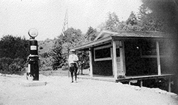
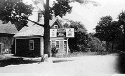
It then went straight (like today’s road) until coming to the area of our lower or eastern driveway, where it went to the right, and again was closer to the brook. This was necessary, because in 1824, there were no railroad tracks on the left (south), so Marston Hill was still intact and came down steeply and close to the brook on this side. Also at that time, of course, the present road and our current house were not there, and possibly neither was the little house with its outbuildings close to the brook (see the photos).
We have deeds for this older house which go back to the 1860s, but we are not sure when it was actually built, although I’m guessing not until after the coming of the Brook Road. The original road’s path was pretty much the same as the current dirt road which circles around the back our present house. Thus it headed south briefly, coming out about where our western driveway is, and crossed where today’s road and rail trail are – which again were not there at that time.

Brook Road next turned to the west and crossed the brook. The stone work which supported this bridge is still in place today and can easily be seen from the rail trail. It is a true testament to the workmanship of its time – built without mortar, and still in place today after almost 200 years, despite spring freshets, the flood of 1936, and the hurricane of 1938!
The road then followed the brook (to the left or south of today’s rail trail) until a short distance before where today’s highway S-curve and bridge passes over the rail trail. At this point it turned right and continued west on the right side of the brook and on to Dyer’s Crossing.
This section of the road can be accessed today, either from the rail trail or by following the road at the turn-off area on the right of today’s highway just beyond the Clay Bank. Each year, in either early spring or late fall, I like to walk along the Brook Road which, although overgrown, is still discernible by its flatness and by the stonewalls which line it in some places and shore it up in others.
The section of road closest to Dyer’s Crossing had a fairly long section of wooden fence which ran between the road and the tracks. Part of this fence is still standing and is even visible from today’s highway, especially at this time of year.