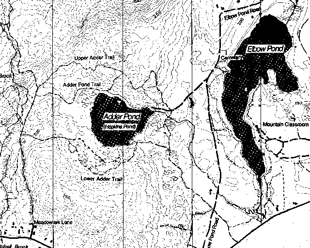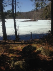
One special place in Andover is a pond that is at once surprisingly close to Andover Village and busy Route 11 and yet unfamiliar to many townspeople and visitors. This is the pond (confusingly) known by some as Hopkins Pond and by others as Adder Pond.
Though Proctor Academy owns the land surrounding it, the pond itself, like all water bodies in New Hampshire, belongs to the State, and New Hampshire Fish and Game (NHF&G) owns and provides public access to the pond by means of a short right-of-way road off of Elbow Pond Road. The residents most familiar with the pond are fishermen and canoeists who enjoy its tranquil water and beautiful setting.
However, the pond itself is but the most dramatic of several natural and features that occupy a natural bowl criss-crossed by trails and woods roads and enclosed to the north and south by steep forested hillsides and to the west and east by lower hills. This area is transitional between the steep slopes that rise up to Ragged Mountain to the north and the relatively flat, sandy soils that extend towards Elbow Pond and the Plains to the Blackwater River.

Unlike those lands to the east and southeast, the area that surrounds and includes Adder (Hopkins) Pond provides an ever-changing series of landscapes and forest types. Rocky outcrops, large glacial erratic boulders, small hills and valleys, vernal pools, red-maple swamps, and areas carpeted by perpetually-soggy sphagnum deposits are all found just off the trails that cross the area from east to west.
The margins of the pond, too, are varied – in places, a low, rocky shore offers unobstructed access and views of the pond and the dramatic hills that rise up seemingly on all sides of it. In other places, shrubby or forested wetlands form the shoreline and extend inland. These offer conditions ideal for many species of fish, amphibians, reptiles, small mammals, and birds.
In any number of short walks in the area of Hopkins Pond, a large number of plant and animal habitats will be encountered, so lovers of birds and wildflowers will rarely be disappointed. Of particular interest may be the area along the pond’s outlet stream. Where once a small concrete dam controlled the level of the pond, extensive beaver activity has created a series of small ponds and dams.
As if this natural variation were not enough, the area around the pond is actively managed by Proctor Academy in the spirit of modern multi-use forestry practices. The rocky slopes to the north, west, and south of the pond are managed to take advantage of the timber and wildlife values of the mixed hardwoods and hemlocks that predominate there and to protect the quality of the ground- and surface-waters that feed the pond. Timber harvests and clearings intended to increase habitat diversity are done on a small scale and selectively.
To the east and southeast, however, relatively flat, deep sandy soils favor the growth of white pine and different forestry practices. Visitors to the area southeast of the pond can see two distinct operations that were carried out recently: A large clearing (about two acres) was made two-and-a half years ago to promote the growth of poplar, a tree that thrives in open sunlight and is quick to establish itself in natural or man-made clearings. Grouse and many other game and non-game species find food in the buds and seeds of these trees.
This year, an additional acre was cleared adjacent to the first to create age-diversity in the clearing. Then, last fall, Proctor Forest manager, Dave Pilla, noticed that the coming year promised to be a major seed (pinecone) producing year, and he made the decision to initiated a major “shelterwood” operation. Conditions that most favor natural white pine regeneration are lots of sunlight but enough mature pines to provide some shelter, along with an uncluttered “scarified” forest floor. (The surface layer is covered with shallow cuts and grooves that allow seeds to reach mineral soil without removing the protective organic layer completely.)
When the operation concludes this spring (probably by the time this article is published), anyone interested in seeing and understanding a “shelterwood” operation will find a walk through this area instructive.
It is no accident that the woodlands surrounding Adder Pond are a sort of classroom for forestry practices; among Proctor’s management goals, education ranks high on the list. Healthy outdoor activity is another, and the school’s popular Mountain Biking program builds bridges and keep trails open for their use and welcome the public to enjoy them, too.
Anyone who would like to begin exploring the pond and its surrounding area might best begin at the NHF&G access off of Elbow Pond Road. A sign in a clearing on the west side of the road, a little less than one mile north of Route 11, makes the access road easy to identify.
From the clearing at the end of the road (if you arrive by vehicle, please park along the access road, not in the clearing itself) a small path heads west, hugging the pond’s northern shore, passing an established camp/picnic site and providing a pretty view of the pond’s only (and tiny) island just off this shoreline. The path, known as Middle Hopkins Pond Trail, runs from the NHF&G access past the pond and another quarter-mile or so through woods to a well-established woods road that is an extension of Meadowlark Lane.
Two other trails also connect Elbow Pond Road to this woods road; one of these (Lower Hopkins Pond Trail) passes to the south of the pond, staying on relatively high ground, providing glimpses of the water through hardwood forest; at one point it comes within about 100 feet of the water at another attractive campsite, before working its way through pine woods to Elbow Pond Road.
A third trail (Upper Hopkins Pond Trail) connects to the woods road just a bit north of the Middle trail, but then climbs up and down low hills to the north of the pond. It eventually connects to the NHF&G access road 200 feet or so to the east of the landing and clearing.
The west end of each of these trails is marked by a wooden sign along the Meadowlark Lane woods road, and this would be another good way to begin exploring the area. Note, however, that this road has limited access for vehicles, and even when conditions permit, a gate prevents vehicles from proceeding far up it. It would be best to park along the short paved section of Meadowlark Lane, being careful not to block access for residents and vehicles engaged in forestry activities in the area.
Visitors are reminded that both NHF&G and Proctor invite the public to use the pond, its shores, and the land surrounding, but they ask that trash be carried out, especially from the access points and camp/picnic sites.
And finally, the author solicits information about the origins of the name Hopkins Pond as an alternate to Adder Pond. Old maps of the town, as well as maps produced by most federal agencies, use the name Adder Pond. But recent usage, and especially the signage and publications produced by New Hampshire Fish and Game, prefer Hopkins Pond. Can anyone shed light on the subject?
If you can help with that mystery, please e-mail me at AndoverNaturally@nullgmail.com. And don’t forget to send in news, photos, questions, etc. about the natural world here in Andover.