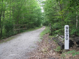
An earlier article described the whistle posts that are being restored along the Northern Rail Trail. A related project is to restore another set of markers – those that identify the bridges along the line.
These bridge markers are concrete posts, each about five feet tall, that have engraved numbers arranged vertically. There are two numbers, then a bar, then two more numbers. These give the distance to that bridge in miles from Boston’s North Station.
The top two numbers are the miles; the bar is like a decimal point; then the lower two numbers are the decimal fraction of a mile. So 96/90 would mean 96.90 miles from Boston.
Similar posts mark the locations of culverts. These posts are shorter and narrower, but have similar mile markings.
Since the Northern was laid out to maintain a maximum of a 1.0% grade, the surveyors followed river and stream beds whenever they could. So the line climbs up from the Merrimack River in Franklin, following Chance Pond Brook and then Sucker Brook, to a summit near West Shore Drive in Andover.
From there it descends into the Blackwater River valley and follows that course and its tributary, Frazier Brook, up to a summit in Danbury. Then it descends into the Smith River valley and follows that stream up to the famous Orange Summit, the overall maximum elevation of the line.
Continuing westward, it follows the Indian River down to Mascoma Lake, and then goes down along the Mascoma River to Lebanon and the Connecticut River.
Considering that the line follows many rivers and streams, it is not surprising that there are quite a few bridges along the way. Some of these bridges are steel structures with their own style of markings. But many are modest stream crossings, and quite a few still retain their bridge marker posts.
These bridge posts testify to the amazing ability of the surveyors to plot a course for the line that satisfied the maximum slope specification and yet kept the distance to a practicable length, considering that the line crossed over the total rugged width of the state of New Hampshire, from the Merrimack River to the Connecticut River.
I have just begun restoring these markers, starting with those nearest my house. It is a slow process. Many are overgrown with small trees and other growth that has to be hacked away before restoration can begin.
If anyone wants to assist in this project, it would be very helpful if they would select a bridge post near their house and clear all the undergrowth from around it. They could then send the mile point number of that post to me (via The Andover Beacon) and I could then complete the restoration painting.