My previous article told of the Northern Railroad’s arrival in 1847, and how the trains jeopardized the lives of the Brook Road travelers. Action was begun in 1903 to relocate a section of the road away from the railroad tracks. This move eliminated two of the dangerous crossings, giving the road travelers a safer route to follow.
To make room for the second path, the shoulder of Hogback was carved back, and the excavated clay became the road’s foundation. As a result, this area of the road was very unstable. Problems occurred during the spring mud season and any time there were heavy rains.
This wasn’t too big a problem initially, when the primary means of transportation was still the horse-drawn wagon. After all, the early travelers were used to dealing with muddy roads!
It was another matter, however, during the 1920s, as more and more of the horse-drawn wagons were being replaced by automobiles. Heavy rains washed clay from Hogback’s embankment across the roadway. During the spring mud season, the road seemed to become a bottomless pit. Regular mud was difficult enough to deal with, but wet clay seemed to turn the road to grease.
These conditions were very challenging and annoying to the automobiles drivers. Work crews, with teams of horses and dump carts, were constantly needed to haul gravel to fill the numerous ruts and mud holes. Often it was necessary for teams of horses to pull stranded cars across this troublesome area.
In order to rectify these problems, work was begun in 1929 to once again change the path of the road. To improve these conditions, it was decided to build a cement highway – the only one ever built in town. This road would become Route 11 as we know it today.
It closely followed the railroad tracks, running parallel to them for some distance. To make room for the road, another section of Marston Hill was sliced away. This excavation included a piece of my parents’ southern-most property.
The road then crossed Sucker Brook and proceeded around Hogback, on about the same route as that taken by the second path. The road crossed Sucker Brook again, before the start of an S-curve. In the middle of this curve, the road went over the railroad tracks on an elevated bridge.
This was a significant improvement, as it eliminated the dangerous Dyer’s Crossing. After the curve, the road straightened out, and passed through land that was originally part of Halcyon Hills Farms on Marston Hill.
This third path rejoined the previous road in the middle of Morey Hill – or about where today’s Hoyt Road sign is located. According to Ralph Chaffee’s history, the first section of state highway in Andover to be given a surface of bituminous tar occurred in 1924. It ran from Morey Hill westerly through East Andover Village.
Thus the completion of this third path around Hogback linked these two new and improved roads. This was a welcome relief for the weary road travelers, who could now easily make their way to and from Franklin and East Andover!
Keeping Up with the Changes
This latest change in the path of Route 11 greatly affected the lives of my parents. Married in 1927, and expecting their first child in the summer of 1929, they decided it was time to buy a house of their own. In June of 1929, they passed papers on the little house and barn near the brook.
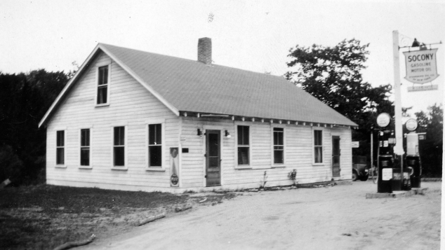
The property included a store and gas station, which my parents thought would be a good little side business for them. Imagine their surprise, then, when shortly after making their purchase they discovered that the road was about to be rerouted through their property and away from their roadside store and filling station!
Surely, people traveling on this new highway would not want to go out of their way to stop for food and gas. Most likely, they would pass right by the property before realizing it was even there.
After much discussion, my father approached the people in charge of the road project and asked if they would level off the area between the old road and the new road for him. They agreed, and my parents started making plans to build a new house/store/gas station beside the new road. Their new house would include a large front room which would be used as the store.
After much work, but before the house was completely finished, my parents made the move in May of 1930. It had been their goal to have the filling station and store open for the Memorial Day Weekend, and they did. Unfortunately, it was a cold, rainy weekend, causing most people to stay home. Not one traveler stopped for service that weekend! Luckily, business did pick up, and my parents operated the store for 10 years.
In 1940, my parents decided it was time to close their little store and gas station. My father was working a regular full time job – as he had right along – and my mother had just had their seventh child. It was time to concentrate on family. The room which had once been the store became our living room!
The Future
Will there be a fourth path or change between the Andover/Franklin town line and Dyer’s Crossing? Quite possibly.
A couple of years ago, surveyors were observed in the area of the S-curve and its bridge over today’s rail trail. The nearby trees and bushes were suddenly decorated with colored ribbons. This leads me to believe that in the not-too-distant future, there will be a fourth path!
[Editor’s Note] Rita’s right. According to the New Hampshire Department of Transportation, the bridge on the S-curve was built in 1929 and is currently classified as functionally obsolete. The eventual relocation of the road intends to shift the alignment to the north so that a new bridge can be built in its entirety while keeping the current bridge in use until all traffic is ready to be shifted to the new alignment.
Since work isn’t scheduled to begin until 2019, this alignment has not been presented to the Town for its input, so there is a long way to go before anything is finalized. But it appears that we will, someday, see a fourth path for Route 11 around Hogback.