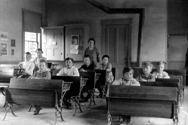
Pond School near Webster Lake at the eastern end of today’s Hoyt Road. My mother, Dorothy Hersey (age 13), is in the back on the left, and her brother Samuel (age 11), is in front of her. They attended the Pond School in 1921 and 1922, walking all the way from the Hersey Farm in East Andover. Their teacher was Claribel Fish (later Yeaton) of East Andover. Caption: Rita Norander
My first Hoyt Road article was about the western half of the road – from Route 11 to Dyers Crossing – and included the two houses beyond the crossing. The article’s main focus was the Hoyt family, for whom the road was named. In this article we will continue our easterly journey along this road to where it dead-ends at the top of the hill.
The Philbrick Road
Just beyond the Keniston and Hoyt houses, there are two roads which intersect or branch off from Hoyt Road. The first one is on the left and is called the Philbrick Road. This road runs north of the Center Road, but more or less parallel to it, and comes out on today’s Route 3A in Franklin, where it is known as Old Call Road. This would have been a much shorter route than the Center Road for Dyers Crossing-area people who needed to travel in a northerly direction. Although there were houses on the Franklin end of this road, Ralph Chaffee in his History of Andover states that to his knowledge there were never any houses on the Andover end.
On the 1879 map of Andover, the southwestern side of Philbrick Road is labeled “Great Pasture,” and farther to the northwest the area is called “Mountain Pasture.” Despite much research, I didn’t discover a reason for the name Philbrick Road. There were Philbricks, who were early settlers on Taunton Hill. Did they possibly own land on this road, where they pastured their cattle during the warmer months, and eventually the road took on their name? Or did some of their descendants settle in this area, leading to the name?
Here is another possibility – according to John Eastman’s History of Andover, “On September 1, 1779, Joseph Philbrick, Paul S. Marston, and Philip Mitchell were chosen as a committee to lay out roads, and they located and relocated the principal roads in town that year.” Did Mr. Philbrick possibly name one of these roads after himself? Several good questions, but no definitive answers!
In 1935, the Philbrick Road was added to the town’s growing list of roads subject to gates-and-bars. According to Ralph Chaffee: “Former roads no longer needed could be disposed of by the town meetings in two ways – either eliminated entirely by a vote of discontinuance or, if there was no reasonable objection on the part of abutting landowners, by subjecting them to gates-and-bars and thereby retaining public ownership of the right of way but relieving the town from further obligation for maintenance.”
The Philbrick Road was another Andover road where Bob and I often traveled in the Jeep. The road was in fairly good condition, and it was an interesting and unique way to travel north.
But my favorite reason for liking this road was the vista point along the way, which provided a terrific view of Webster Lake. I’ve often wondered if this view is still there, or has it been obscured by the ever-growing trees? Eventually, logging took place along the Philbrick Road, making travel difficult even by Jeep. Today, horseback riders and snowmobilers enjoy the road.
Brook Road
The second road which intersects with Hoyt Road is a little farther east and branches off to the right. This is the former Brook Road, the same road mentioned in earlier articles. It began near the Franklin-Andover town line and followed the brook around Hogback before joining up with today’s Hoyt Road.
This was the main road up until 1929, when Route 11 was relocated. Today, snowmobilers use this little section of Brook Road as a shortcut from the Rail Trail to the Philbrick Road, and then on to Old Hill Village, Newfound Lake, and other points north.
The Top of the Hill
Hoyt Road now ends at the top of the hill, but as mentioned in my Center Road article, this was once a busy through-road. The first settler on this hilltop land was probably Isaac Brown who, according to Ralph Chaffee, “built a modest house or cabin and started to clear the land as early as 1781.”
John Eastman says that Isaac “settled at the top of the hill on the old road going to Franklin and built and operated a sawmill on Mill Brook in Hog Back.” Later Jacob Weare made his home here for a number of years. The Weares were early Andover settlers, and there were numerous branches of the family in various parts of town.
Edgar Taylor and his family were the owners of the farm when my parents bought their property in 1929. The two properties abut each other, being separated by Sucker Brook. The Taylor’s land included Hogback, and extended all the way down to the railroad tracks, and the brook which was their southern boundary line.
I remember my mother telling me that the Taylors used to plant potatoes in the patch of land between the railroad tracks and the brook, since the soil conditions were just right for this particular crop. I have always found it hard to picture anything growing there, since today the land is so overgrown and closed in, but I’m sure it wasn’t back then.
When I was growing up, Clarence Rayno was the owner of the hilltop farm. He, too, was a Keniston cousin, a bachelor and quite a character. He was pleasant and friendly, but I’m afraid he wasn’t known for taking very good care of his property!
He was the owner of Hogback when the Franklin Flood Control Dam was built in 1940. The federal government took 12.3 acres of his land in order to use the clay for the building of the dam. Clarence contested the money offered by the government, and the case dragged through the courts for several years.
Eventually the case was settled, and Clarence bought a farm in Sanbornton, while still owning the East Andover farm, where he grazed some of his cattle. Thankfully, subsequent owners of the hilltop farm have brought the property back to life.
Up Hoyt Road and Over Great Hill
One day late last summer I went for a walk on the rail trail from my house to Dyers Crossing. Then I decided I’d walk up Hoyt Road, to the top of the hill.
It had been several years since I had walked down the other side towards Webster Lake, so I ventured on. This was not a very wise decision, as the old road is very, very overgrown, rutted, and steep. Once I had started my descent, there was no turning back, as it was easier to continue bushwhacking down hill than to try to go back up.
Finally I made my way to the bottom of the hill, coming out on Apple Farm Road, near the old Marcy Farm where my father had worked for so many years. It was an interesting walk, but not one I would repeat or recommend to others!
Over Great Hill in 1921
My walk up and over Hoyt Road reminded me that long ago, my mother, Dorothy Hersey, made this trek every school day for a year.
Dyers Crossing School closed in 1921 because there were so few students. The remaining children were to attend school in East Andover, but for some reason my grandfather did not want my mother and her brother Samuel to go there.
Instead, their father enrolled them at the Pond School near Webster Lake in Franklin. The building still stands on Apple Farm Road today – the house across from the little cemetery.
Every morning, my mother and my Uncle Samuel walked from the Hersey Farm to the top of Hoyt Road and then down the other side to the little school in Franklin. Every afternoon, they retraced their steps.
It was a long, long walk and up and down a very, very steep hill. In their case, it was definitely true about how far they walked to school in the old days, and it was indeed up-hill both ways!