Brochure here: ausbonsargent.org/sites/default/files/upload/earth_day_hikes.pdf
To celebrate the 50th anniversary of Earth Day, Ausbon Sargent invites you to explore some of the beautiful lands that you have helped preserve. Following are eight self-guided hikes in eight different towns. Each of the trails are well-marked with available parking and are perfect for self-guided hikes on your schedule. Directions to each hike are at: www.ausbonsargent.org/calendar.
Bradford: Bradford Bog. The .3 mile boardwalk winds through a rare Atlantic White Cedar swamp with many native wildflowers until it reaches a wooden viewing stand. Climb up to enjoy great views over the bog to Lovewell and Haystack Mountains. Back at the parking area, head south on East Washington Road to visit the site of the former Bradford Springs Hotel, marked by a kiosk and plaque and cellar holes.
Goshen: Ruth LeClair Memorial Trail. This 3-mile loop takes you around Gunnison Lake (aka the Goshen Ocean) and passes by Wayne’s Woods, which is protected by Ausbon Sargent. The hike goes through the woods, and along Baker and Blood Brooks, which flow into the lake.
Grantham: Sawyer Brook Headwaters Property. Walk on Croydon Turnpike, about a mile, where you will find an access point to the property. Explore old woods roads to the log landing. From here, take a left onto Dunbar Hill Road which is a class six road that will take you back to Walker Brook Road. Approximately 2.5 miles round trip.
Newbury: Kidder Tract – Sunset Hill Trail. Follow signs for Sunset Hill which initially follow a dirt road and then bear right through a dense wooded area. At the top, you will have lovely west and southwest views of Lake Sunapee and Mount Sunapee. The one-way distance is about .9 mile.

New London: Clark Pond. The trail is about a 1.6 mile loop through the woods with views of Clark Pond. Good for snowshoeing in winter months. There is a kiosk with trail information at the start.

Springfield: Pitcher Hill on Star Lake Farm. Walk uphill past the orange gate and you will see a large wooden sign for Pitcher Hill Hike on the left side. The trail winds uphill through the woods and ends on a rocky top with views of Otter Pond and Lake Sunapee. Roundtrip distance is about 1 mile.
Sunapee: SRK Greenway on Frank Simpson Preserve. Follow the SRK trail blazes to the left of the sign. The trail meanders through the woods, past glacial erratics, next to ponds, and former beaver dams. Walk about 2 miles to the Sunapee playground, 2.5 miles to the Sunapee Town Hall, or retrace your steps when you’ve gone far enough.
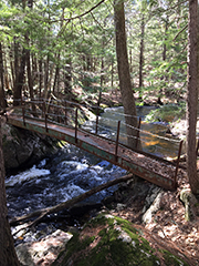
Sutton: Webb-Crowell Forest. The trail is marked with blue blazes and goes into woods, over a unique iron bridge on the Lane River, and then follows a loop back to the same bridge. On the trail there are views along the river, large glacial erratics, and views across the wetlands. Total loop distance is just over 2 miles.
The Ausbon Sargent Land Preservation Trust: Helping preserve the rural landscape of the Mt. Kearsarge/Ragged/Lake Sunapee Region. Serving the towns of Andover, Bradford, Danbury, Goshen, Grantham, New London, Newbury, Springfield, Sunapee, Sutton, Warner, and Wilmot. For more information call 526-6555, or visit the website at ausbonsargent.org.